 Previous Topic
Conditional Formatting Dialog Box
You can use the Conditional Formatting dialog box to add conditional formatting to values of the selected field or to geographic map markers. This topic describes the options in the dialog box.
Designer displays the Conditional Formatting dialog box when you select a field or geographic map in a report and then select Conditional Formatting  in the Home or Format ribbon, or right-click the field or geographic map and select Conditional Formatting from the shortcut menu. Designer provides you with different options in the dialog box for adding conditional formatting for the values of a field or for geographic map markers.
When you use the Conditional Formatting dialog box to add conditional formatting to values of a field, Designer displays the following options in the dialog box:
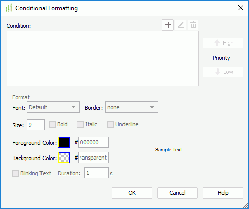
Condition
This box lists the conditions that you add to define the conditional formatting.
-
 Add button
Select to open the Edit Conditions dialog box to add a new condition. -
 Edit button
Select to edit the specified condition. -
 Remove button
Select to delete the specified condition. - Priority
- High
Select to move a condition up for a higher priority. - Low
Select to move a condition down for a lower priority.
- High
Format
You can specify the formatting to apply to the field values that satisfy the selected condition in this box.
- Font
Select the font face of the values. - Border
Select the border line style of the values. - Size
Specify the font size of the values. - Bold
Select to apply bold formatting to the values. - Italic
Select to italicize the values. - Underline
Select to add a horizontal line under the values. - Foreground Color
Specify the foreground color for the values. To edit the color, select the color indicator and select a color from the color palette, or type the hexadecimal RGB value of a color (for example, 0xff0000) in the text box. - Background Color
Specify the background color for the values. - Sample Text
This box displays a preview sample of your selection. - Blinking Text
Select to blink the values.- Duration
Specify how long it takes the field values to complete the transition from the foreground color to the transparent color, in seconds.
- Duration
OK
Select to apply your settings and close the dialog box.
Cancel
Select to close the dialog box without saving any changes.
Help
Select to view information about the dialog box.
When you use the Conditional Formatting dialog box to add conditional formatting for geographic map markers, Designer displays the following options in the dialog box:
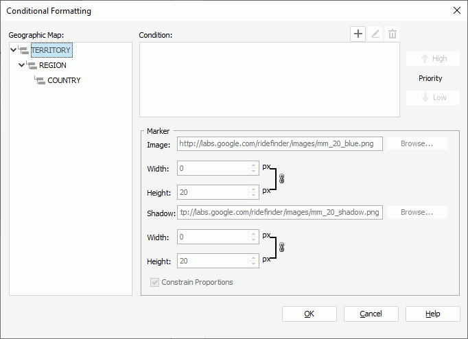
Geographic Map
This box lists all the group levels in the geographic map. Select a group level to edit conditional formatting for its markers.
Condition
This box lists the conditions that you add to define the conditional formatting.
-
Add button
Select to open the Edit Conditions dialog box to add a new condition. -
Edit button
Select to edit the specified condition. -
Remove button
Select to delete the specified condition. - Priority
- High
Select to move a condition up for a higher priority. - Low
Select to move a condition down for a lower priority.
- High
Marker
You can specify the settings to apply to the markers that satisfy the selected condition in this box.
- Image
Specify the image of the markers. You can type the URL for a web image or select Browse to specify a local image.- Width
Specify the width of the foreground image. - Height
Specify the height of the foreground image.
- Width
- Shadow
Designer displays this option only when the geographic map applies one of the Google Maps types. Type the URL for a web image or select Browse to specify a local image as the shadow image of the markers.- Width
Specify the width of the shadow image. - Height
Specify the height of the shadow image.
- Width
Constrain Proportions
If you select this option, when you set the width or height of the marker image/shadow, Designer adjusts the other accordingly in a certain proportion.
OK
Select to apply your settings and close the dialog box.
Cancel
Select to close the dialog box without saving any changes.
Help
Select to view information about the dialog box.
 Back to top